
Wheeling ZIP Coverage, Carefully Labeled
The official Wheeling Post Office listing verifies 26003 as the principal local mailing ZIP. USPS FAST material also places 26031, 26038, 26040, and 26059 in the wider Wheeling-area range. That does not prove each code serves an incorporated Wheeling parcel. A responsible ZIP code directory separates the verified city mailing result from nearby codes that still require an address-level check.
| ZIP Code | Areas Covered | Post Office | Notes |
|---|---|---|---|
| 26003 | Verified Wheeling mailing name | Wheeling Post Office | Principal code; postal line is not the corporate boundary |
| 26031 | Wider Wheeling-area range | Verify through USPS | Do not label a city parcel without an address result |
| 26038 | Wider Wheeling-area range | Verify through USPS | Nearby code, not automatic city coverage |
| 26040 | Wider Wheeling-area range | Verify through USPS | Nearby code, not automatic city coverage |
| 26059 | Wider Wheeling-area range | Verify through USPS | Nearby code, not automatic city coverage |
The dynamic USPS city result did not yield a complete list during research, so no unsupported neighborhood assignment belongs in the table. Confirm a full street and unit in the official tool. USPS warns that a result does not confirm a person or company is present at an address. It standardizes delivery geography.
Search Wheeling Through USPS
The USPS ZIP Code Lookup offers three distinct paths. By Address standardizes a full delivery line. By City and State returns postal codes accepted for the place. Cities by ZIP identifies accepted place or post-office names for a known code. Select the mode that matches the fact in hand.
| Mode or field | Input | Required | Use |
|---|---|---|---|
| By Address: Company | Text | No | Business name when relevant |
| Street Address | Text | Yes | Include the unit when known |
| City and State | Text and dropdown | Yes | Standardize the place line |
| ZIP | Text | No | Narrow or verify an address |
| Cities by ZIP | ZIP code | Yes | Return accepted city names |
The official lookup screen shows these search modes before its dynamic results.
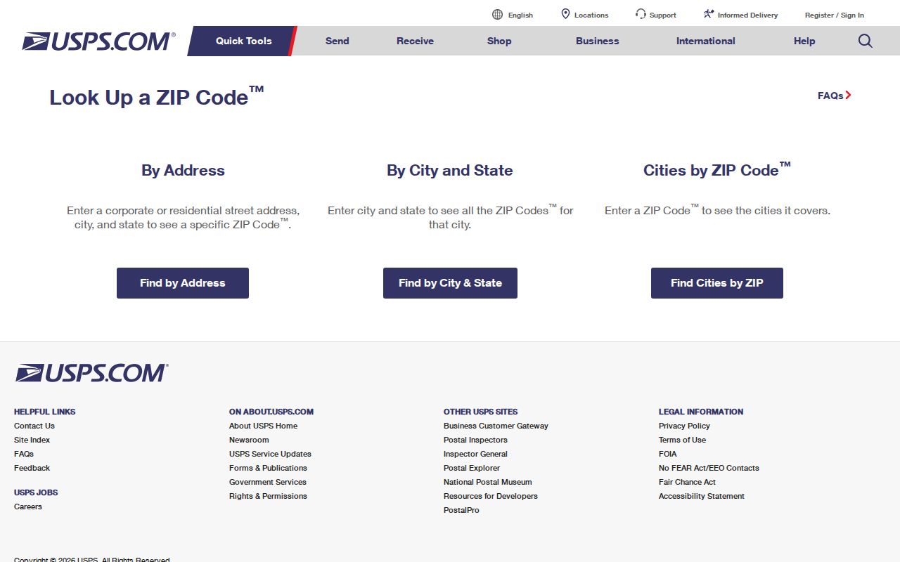
The image highlights why an address search, city search, and known-code search answer different questions.
26003 Anchors Wheeling Mail
The official Wheeling Post Office result gives 2501 Chapline Street, Wheeling, WV 26003-9998. Use that listing as proof of the principal postal relationship, not as evidence that all 26003 addresses fall inside city limits. The final four digits on the post-office address are a ZIP+4 segment, not a second local ZIP.
USPS's Postmaster Finder accepts a From ZIP and To ZIP and returns post-office names, states, establishment dates, and discontinuance history. It is valuable for historical postal context. It does not draw parcel lines or confirm residents.
Note: Keep the date of every postal result because accepted names, routes, and office relationships can change.
Read Wheeling Delivery Types
The USPS AIS Viewer describes monthly products for City/State/Delivery Type, County Name, Delivery Statistics, ZIP+4, and Address Lookup. Delivery types include street, rural, post-office box, general delivery, unique, military, and nonactive. These are postal classes, not labels for local property ownership or civic jurisdiction.
- ZIP code
- A five-digit postal code used to route mail within a delivery geography.
- ZIP+4
- The base ZIP plus four digits that narrow delivery to a segment, building, or group of boxes.
- PO-box ZIP
- A code or delivery type used for post-office box service rather than street delivery.
- Unique ZIP
- A postal code assigned for a single high-volume organization.
- Carrier route
- A group of delivery points served along a postal carrier's route.
The viewer's products are encrypted and non-exportable there. Use them to understand address quality, not to create a public list of Wheeling residents.
Narrow a Wheeling Resident by ZIP
A local search cannot simply feed a ZIP into every official portal. The Ohio County Assessor exposes owner, address, account, district, map or parcel, legal description, and deed book or page fields, but no ZIP field. The statewide voter-status form requires first name, last name, and date of birth, also with no ZIP input. GIS is parcel-centered. Start with USPS, then translate the result into an accepted key.
- Standardize the full street and unit through USPS, and save the returned city, state, and ZIP line.
- Search the Ohio County Assessor by the street address, then note its district and parcel identifier.
- Open the GIS parcel route to compare the physical location with the city and county lines, remembering that mapped boundaries are not a survey.
- For one person's voter status, use the official name and birth-date form. Do not expect a ZIP-wide voter directory.
Once the postal area resolves to a street, the Wheeling streets search explains the address and parcel chain in depth. The ZIP code directory should narrow geography, not replace street-level evidence.
Wheeling Assessor Has No ZIP Filter
The Ohio County Assessor Property Search uses address or parcel facts rather than ZIP. An address result can connect a physical situs address with owner, mailing address, district, map or parcel, legal description, and deed book or page. Situs means the physical tax parcel. The mailing address is where the owner receives tax mail. Those fields can differ.
Use the postal result to clean the delivery line, then search the assessor with street terms. The parcel card helps answer an ownership question, but it does not prove who occupies the place. For paper help, the assessor office and its public counter remain the fallback. GIS adds map context, while recorded deeds control legal ownership.
The distinction also affects family and property research. A parcel's owner may receive mail elsewhere, so its mailing ZIP may describe the owner's correspondence address rather than the Wheeling land. A deed may omit a modern street number and identify the tract through a lot, subdivision, metes-and-bounds description, or adjoining owners. Record all three forms when available: postal line, situs address, and legal description. They provide separate bridges into USPS, assessment, and county land records.
Old Wheeling Directories Precede ZIPs
Modern ZIP codes should not be forced onto nineteenth-century resident evidence. Most Wheeling directories from 1898 onward include a reverse street section, and earlier books rely on names, streets, alleys, trades, and house numbers. The city changed street names and numbers on July 11, 1873. A modern postal line can therefore hide the printed address that an old book actually uses.
Search old material with the period address and the library's renumbering handout. Then use historic maps, the current parcel, and the deed legal description to bridge eras. No official Wheeling-specific ZIP split history was verified, so claims about local realignment dates would be speculation.
The 1901 atlas can add owners, rail and streetcar lines, and water, gas, or sewer context. Sanborn maps can show a building footprint and use. Neither source supplies a postal ZIP for an era before the system, and neither proves the full household. Keep the historic address as printed, use the map to place it, and return to the reverse directory or census for people.
Wheeling Voter Geography Differs
The West Virginia voter-status lookup is a person-specific check. It asks for first name, last name, and date of birth, then may return registration status, party, districts, and polling place. It does not accept a ZIP and cannot produce a ZIP-wide list. Public voter records under state law are organized around registration fields and precinct geography, with exclusions and noncommercial-use limits.
Wheeling's ward structure is another layer. The Sixth Ward includes a Marshall County precinct, while other city precincts fall in Ohio County. A postal code can cross or surround those political units. For one resident, verify postal data first, then use the official voter form with that person's own details. For a broader lawful records request, contact the county elections office and describe the desired fields and precinct rather than assuming ZIP is an available selector.
Wheeling ZIP Lines Versus City Limits
A Wheeling mailing name can extend beyond the corporate boundary. The city itself lies mainly in Ohio County, yet its Sixth Ward includes Marshall County precinct 39. That means a postal search, city government search, parcel search, and election search can point to different geographic units without any source being wrong. The record custodian follows legal jurisdiction, not the familiar city line on an envelope.
- Corporate city
- The legally incorporated municipal area governed by Wheeling.
- Postal city
- The accepted city name used by USPS for delivery, which may cover a different area.
- Taxing district
- The county assessment district attached to a parcel, separate from its mailing ZIP.
- Legal description
- The deed or plat language that identifies land even when a modern street number changes.
Check the city charter or official neighborhood map for municipal context, then check Ohio County or Marshall County based on the parcel. A ZIP-wide assumption can miss records kept across the county line.
The official neighborhood names add useful orientation, but they are not postal zones. Downtown, Wheeling Island, Warwood, Elm Grove, Woodsdale-Edgewood, South Wheeling, and the other mapped areas describe local places. Do not assign one of them to a ZIP without an address-level postal result. The river, island, and valley pattern can also make nearby points look connected on a broad map even when their parcel and delivery routes differ.